
• Work
  • Story
  • Writing
  • Teaching
  • Archive
  • Ping Me
Menu

Niki Selken

  • Work
  • Story
  • Writing
  • Teaching
  • Archive
  • Ping Me

TECHNOLOGY IS NEVER AS NEW AS IT LOOKS.

Computer Picnic is an editorial project by Niki Selken connecting today’s technology stories to overlooked histories in art, media, books, and internet culture.

huntersmapfinal-e1355105605455.jpg

The Long Walk: Mapping Hunters Point, a food desert

October 23, 2012

I know its been a while since I announced The Long Walk, an original Performance/Data collection piece  I created about San Francisco's Food Desert, Hunters Point. However, I wanted to share with you, the finished product of that process. In case you missed that incarnation, here is a little background on the issue I blogged about earlier:

'Unequal access to healthy food based on income and specifically within low-income neighborhoods is a huge problem in America. 2.3 million Americans live over a mile away from a grocery store without access to a vehicle. This has created something known as a “Food Desert” where entire low-income neighborhoods are under-served in access to the basic human right of healthy, unprocessed food. People living in low-income areas spend significantly more time (19.5 minutes) traveling to the grocery store than the national average (15 minutes) according to the USDA. The USDA has also created this Food Desert Locator, albeit somewhat inaccurate as it does not take into account corner stores with fresh fruit and vegetables, it is still a step in the right direction.'

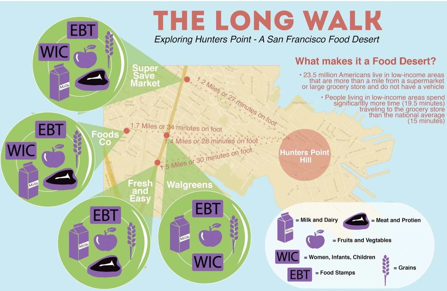
Hunter's Point is listed on the USDA Food Desert Locator and was named one of the "Top 9 Worst US Urban Food Deserts." What I did to examine this issue, is create a visual map and an interactive Google Map that focuses on the Food Desert we have within our city boarders, in Hunter's Point.  The Map I created lists the closest shopping options for the residents of Hunters point, including a key that details the types of food sold and weather or not they support Food Stamps (EBT) and Women Infants and Children (WIC ) coupons for low income mothers. The map also tracks the distance amount of time it takes on foot to travel one-way to the store from the center of Hunter's Point Hill.  Check out the visual map below and the interactive map here.
Source: http://nikiselken.com/wp-content/uploads/2...
Tags design, food desert, hunters point, info graphics
← Dance and Light ExperimentsStuff I'm doing this summer: a poetry series, computer dance, and lots of weddings! →

Subscribe

Thank you!

AI Design

Virtual  Reality

Game Design

Emoji Art and Design

Museum Interaction Design

Thesis

What I'm Thinking About

Parsons MFAD+T Projects

No results found

Fresh Posts

People are literally blocking Flock cameras. What does a book published in 2002 have to do with it? CTRL [SPACE]: Rhetorics of Surveillance from Bentham to Big Brother traces a history from Bentham’s Panopticon to the 2,397 surveillance cameras documented in Manhattan in 1998, JenniCam, and machines that don’t merely record us, they interpret what they see. The book didn’t predict Flock cameras. It gives us the history and vocabulary to understand why the camera at the end of the block is more than a camera. Today, the important question isn’t only how many cameras surround us. It’s what happens after an image is captured: how it is analyzed, connected to other records, stored, and made searchable. The book calls the ability to understand these systems “surveillant literacy.” Twenty-four years later, that literacy feels essential. I wrote more about the book and the history connecting it to the surveillance systems appearing on our streets today. Read “The Camera at the End of the Block” and find links to borrow or buy CTRL [SPACE] at the link in my bio. Flock protest photograph: Meg Anderson/NPR. #ComputerPicnic #FlockCameras #Surveillance #DigitalCulture TechnologyHistory
DATALAND did not appear from nowhere. In 2016, Gray Area and Google presented what has been described as the first exhibition of generative AI art. That same year, Meow Wolf opened a world audiences could physically enter. Later, through Gray Area’s Experiential Space Research Lab, I explored how immersive environments could do more than entertain. They could encourage agency, critical thinking, and new relationships between people, technology, and living systems. Now Refik Anadol’s DATALAND brings those histories together through AI, environmental data, biosensing, and responsive space. The biggest shift is not simply that AI has entered the museum. The museum itself is becoming a living system. I wrote about the longer history behind this Reel, what excites me about DATALAND, and the ethical questions a responsive museum must confront. Read the full story through the link in my bio. #DATALAND #RefikAnadol #AIArt #ImmersiveArt #DigitalArt #MuseumFuture

What I'm Thinking About

  • AI Design (1)
  • Arts for Survival (1)
  • Computer Picnic (1)
  • DJing (1)
  • Ko Labs Theater Collective (1)
  • Music Blog (1)
  • Teaching (1)
  • VR (1)
  • Game Design (2)
  • MUSIC (2)
  • Museum Interaction Design (2)
  • Wearables (3)
  • PERFORMANCE (4)
  • Web Design and Code (6)
  • Major Studio 2 (10)
  • Design (16)
  • Parsons MFADT (16)