• Work
  • Story
  • Teaching
  • NFTs
  • News and Press
  • Ping Me
  • CV
  • Blog
Menu

Niki Selken

  • Work
  • Story
  • Teaching
  • NFTs
  • News and Press
  • Ping Me
  • CV
  • Blog
huntersmapfinal-e1355105605455.jpg

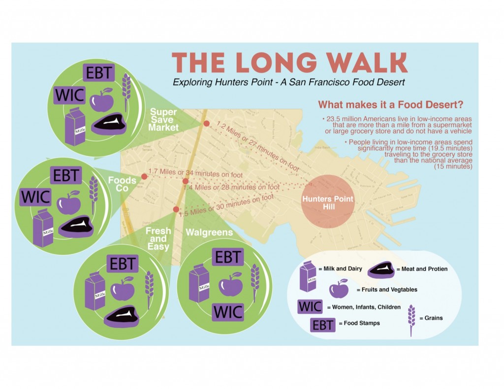
The Long Walk: Mapping Hunters Point, a food desert

October 23, 2012

I know its been a while since I announced The Long Walk, an original Performance/Data collection piece  I created about San Francisco's Food Desert, Hunters Point. However, I wanted to share with you, the finished product of that process. In case you missed that incarnation, here is a little background on the issue I blogged about earlier:

'Unequal access to healthy food based on income and specifically within low-income neighborhoods is a huge problem in America. 2.3 million Americans live over a mile away from a grocery store without access to a vehicle. This has created something known as a “Food Desert” where entire low-income neighborhoods are under-served in access to the basic human right of healthy, unprocessed food. People living in low-income areas spend significantly more time (19.5 minutes) traveling to the grocery store than the national average (15 minutes) according to the USDA. The USDA has also created this Food Desert Locator, albeit somewhat inaccurate as it does not take into account corner stores with fresh fruit and vegetables, it is still a step in the right direction.'

Hunter's Point is listed on the USDA Food Desert Locator and was named one of the "Top 9 Worst US Urban Food Deserts." What I did to examine this issue, is create a visual map and an interactive Google Map that focuses on the Food Desert we have within our city boarders, in Hunter's Point.  The Map I created lists the closest shopping options for the residents of Hunters point, including a key that details the types of food sold and weather or not they support Food Stamps (EBT) and Women Infants and Children (WIC ) coupons for low income mothers. The map also tracks the distance amount of time it takes on foot to travel one-way to the store from the center of Hunter's Point Hill.  Check out the visual map below and the interactive map here.

Source: http://nikiselken.com/wp-content/uploads/2...
Tags design, food desert, hunters point, info graphics
1 Comment
food_desert1.jpg

The Long Walk: An Invitation to Explore A San Francisco Food Desert

April 23, 2012

Unequal access to healthy food based on income and specifically within low-income neighborhoods is a huge problem in America. 2.3 million Americans live over a mile away from a grocery store without access to a vehicle. This has created something known as a “Food Desert” where entire low-income neighborhoods are under-served in access to the basic human right of healthy, unprocessed food. People living in low-income areas spend significantly more time (19.5 minutes) traveling to the grocery store than the national average (15 minutes) according to the USDA. The USDA has also created this Food Desert Locator, albeit somewhat inaccurate as it does not take into account corner stores with fresh fruit and vegetables, it is still a step in the right direction.

To examine these inequalities I am creating a performance walk and interactive mapping project. “The Long Walk” will focus on the Hunters Point Food Desert that exists on local level, within the San Francisco community. This piece will combine a two and a half mile walk and shopping trip from the center from Hunter’s Point Hill to the Super Save Market and back, combined with an interactive web map recording the experience. At the market, which is the closest market to the center of Hunter's Point, I will purchase enough food for three days meals and carry the groceries back on foot.

You are invited to walk with me. 

The walk will act as metaphor for labor and duration. I want to express the labor and work it takes residents of low-income neighborhoods to access healthy food, that is so much more accessible to those that live in better serviced neighborhoods. While we walk I will document the  four mile walk with geo-located photography and journaling. I will also record the number of steps we take and create step markers every 500 steps on the map. Our pictures, thoughts and memories will be captured and mapped the published on the web.

Meet me at 12 noon on Sunday April 29th @ Kirkwood Ave @ Earl Street

The Long Walk starts at 12:20 and we should be back to the Hunters Point starting point by 3pm.

Bring comfortable shoes, a cellphone or camera and water.

For more info email niki@nikiselken.com  or call 415.692.1322

Source: http://nikiselken.com/wp-content/uploads/2...
Tags classism, food desert, food justice, hunters point, niki selken, racism, the long walk
3 Comments

Subscribe

Thank you!

Wearable and Physical Tech

Virtual  Reality

Game Design

Emoji Art and Design

Museum Interaction Design

Thesis

What I'm Thinking About

Parsons MFAD+T Projects

Fresh Tweets

  • ✨ ηιкι ѕєℓкєη ✨ nikistyxx.eth/tez
    RT @letsglitchit: My talk at not.glitch presented here in text format for accessibility Title: Can We Glitch Sotheby’s Hi everyone… https://t.co/wtHiadJ79m
    Apr 3, 2023, 1:40 PM
  • ✨ ηιкι ѕєℓкєη ✨ nikistyxx.eth/tez
    Here are my early experiments with Adobe Firefly Beta. They have an interesting textured text generator.… https://t.co/0LsTE76Qzv
    Mar 27, 2023, 3:34 PM
  • ✨ ηιкι ѕєℓкєη ✨ nikistyxx.eth/tez
    RT @habitual_truant: Love! 👏 To! 👏 See! 👏 It! 👏 ❤️ @GrayAreaorg ❤️ https://t.co/oABypAWCUi
    Mar 20, 2023, 12:51 PM

What I'm Thinking About

  • Arts for Survival (1)
  • DJing (1)
  • Ko Labs Theater Collective (1)
  • Music Blog (1)
  • Teaching (1)
  • VR (1)
  • Game Design (2)
  • MUSIC (2)
  • Museum Interaction Design (2)
  • Wearables (3)
  • PERFORMANCE (4)
  • Web Design and Code (6)
  • Major Studio 2 (10)
  • Design (16)
  • Parsons MFADT (16)